Maps
A Selection of Online Maps and Other Map Resources for Trail Camera Users
It makes sense to plan you trail camera deployment before going live. Maps are really useful from a number of different perspectives. It's good to see where to park and which walking routes to take.
 |
From studying the foot paths you can work out where a good area deploy may be which minimises the risk human discovery of your valuable camera.
Contour lines and watercourse marking will also help you plan. One of the best features of most online maps is the Ariel View facility.
Many of the services allow you to create you own maps, draw you own routes and place markers. Some are public visible, some allow private routes.
|
Clearly it's common sense not to share the location of your camera on a public map!
Below are our favourite map resources; if we've missed one you think belongs here, please let us know using the form at the bottom of the page.
Map Resources
|
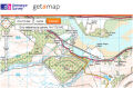 |
You'd expect the Ordnance Survey to be one of the top players in this arena, and they don't let you down. Their Get-a-Map resource allows you to view OS maps with their rich resources, plan and draw routes to save and share, switch to ariel views and zoom right down. We make good use of this service regularly. |
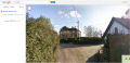 |
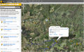
Google has a very unique and special tool bundled within their Google Maps resources; Street View. Google Street View allows you to explore area with your mouse as if you are really there. You can move along roads, pan tilt and zoom the camera. See the 'Street View Example' lower down the page. |
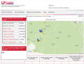 |
If your trail camera has the ability to send images via email or MMS, it will only do this will in an area of good reception. Use the Ofcom Site finder Mobile Phone Base Station Database Map to see where the nearest cell mast for your operator for your planned deployment. We now alternate between Sim cards, depending on what this map shows regarding our prospective site.
|
 |
The Walk Jog Run website is used by hundreds of thousands of people plan and share their routes. You can view everyones routes online. Use this resource for both planning walks, but also to avoid popular routes; wildlife will avoid these areas, and your trail camera will be more exposed. |

|
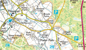
It's always best to have a paper Ordnance Survey map of the area you wish to deploy your camera in. We love the option to have your own Ordnance Survey Custom Map, with your house (or any location you choose) right at the center of the map, and your own title/subtitle cover too.
|
Google Street View Example
View Larger Map
|
|
Wildlife Cam

Promote your Page too
|